 Filter: Categories of Wisconsin Historical Images
Filter: FORMAT_DIMENSIONS of 32 x 40 cm.
Filter: Categories of Wisconsin Historical Images
Filter: FORMAT_DIMENSIONS of 32 x 40 cm.
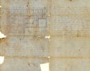
| Date: | 08 1851 |
|---|---|
| Description: | Ink on paper. Includes explanation and a certification signed by Jacob Marty, Electa Marty, and a justice of the peace. Original map is very light and in f... |
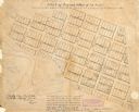
| Date: | 1840 |
|---|---|
| Description: | This map of La Crosse is ink and pencil on paper and shows lot and block numbers, as well as buildings. An inscription on the bottom of the map reads: "Tim... |

| Date: | 1900 |
|---|---|
| Description: | This map shows a paper city located where "Grass Creek" meets the Pecatonica River, probably in Iowa County. Number lots and streets with dimensions are sh... |

| Date: | 1792 |
|---|---|
| Description: | Map of the United States east of the Mississippi River and north of the Ohio River. It shows the borders between the north eastern states, Canada and the U... |
If you didn't find the material you searched for, our Library Reference Staff can help.
Call our reference desk at 608-264-6535 or email us at: